Timber Investigation Centre — Resources
Tech for identifying species & origin
Technologies for species identification
Wood anatomy: This relatively simple method entails examining a cross section of the surface of a solid wood product using a handheld lens or microscope. The pattern of cells and pores can be compared with reference information to identify the genus or species. This method has significant limitations. How precise a judgement can be made depends on the level of variation between species and the availability of reference imagery. It can also be expensive, since it traditionally requires extensive time commitments from highly trained wood anatomists. Automated portable systems useable by non-experts have been designed, but are at an early stage of development and at present only applicable to a small range of wood species. Wood anatomy is also only possible for solid wood products.Fibre analysis: Can be used for paper and pulp
products, where individual wood fibres are examined under a microscope. Though
it is rarely possible to distinguish down to the level of species using fibre
analysis, it can be used to determine whether natural tropical forest wood is
contained within a sample claiming to be made solely from plantation-grown
wood.[1]
DNA analysis: Theoretically the most reliable
method of species identification, but more expensive than wood anatomy. It is
also dependent upon incomplete reference information, and on it being possible
to extract useable DNA from a product.
Spectrometry: Potentially cheaper and easier than wood anatomy or DNA, this technology identifies the species based on how it reflects and absorbs different wavelengths of light. Reference databases for this methodology are even less well developed than for the others, however.
Establishing geographic origin
DNA analysis: Can in theory also be used to narrow down the geographic origin of a sample of a given wood species, based on natural variation in the DNA of individuals of a given species over its geographic range.Stable Isotope Analysis: Uses the natural variation in the proportion of different versions of atomic elements such as carbon in individual wood samples, which varies along with the soil in which the trees grow.
Both methods hold great potential, but their applicability
is restrained at present mainly by the absence of reliable reference databases
of samples of known geographic origin. Even where such reference databases
exist, they may not be of sufficient resolution to be able to determine
geographic origin information of sufficient detail to be of use in establishing
legality or illegality. The only example to-date of such databases being used
in relation to legality is the use of isotopes to determine whether oak
originates from the Russian Far East or neighbouring areas of China.[2]
DNA and isotope databases have also been developed for the
most heavily-traded tropical wood species from Central and West Africa, though
it appears that their resolution is only sufficient to at best determine
country of origin.[3] Databases sufficient to demonstrate
country of origin for a number of other major tropical wood species from Asia
and Latin America, including Merbau[4], teak and mahogany[5] have also been developed. Whether
DNA or isotopes can be used to reliably determine geographical origin more
precisely, such as to an individual district or logging concession, remains an
open question. Attempts to test the ability to use such databases to determine
concession of origin of Merbau in Indonesia[6] and Iroko and Sapele in Cameroon[7] did provide some cause for hope,
though the confidence levels obtained (around 70%) would be insufficient for
prosecutions, and it is unclear whether the level of sampling needed to reach a
more meaningful level of confidence is practicable.
At the time of writing, costs in the EU of species
identification of a solid wood sample using wood anatomy were approximately
US$100 – $200 per sample, DNA analysis around $300 – $700 per sample.[8] Isotopic tests to verify origin also
cost around $200-$500 per sample. It can take anywhere from a few days to a few
weeks to obtain results, depending on various factors.[9]
[1] Adam Grant, Ruth Nogueron and Craig Hanson, Q&A Fiber
Testing-Paper and The Lacey Act, World Resources Institute blog, 2011 http://www.wri.org/blog/2011/01/qa-fiber-testing-paper-and-lacey-act
[2] EIA, ‘Liquidating the Forests: Hardwood
Flooring, Organized Crime, and the World’s Last Siberian Tigers, 2013, http://eia-global.org/images/uploads/EIA_Liquidating_Report__Edits_1.pdf
[3] Degen, B. & Bouda, H., ‘Verifying
timber in Africa’, ITTO Tropical Forest Update 24/1, 2015.
[4] Double Helix, The State of DNA
Technology for Trees and Wood Products, 2011 http://www.illegal-logging.info/sites/default/files/uploads/DoubleHelixAppliedGeneticsForForestsReport072011.pdf
[5] Scheliha and Zahnen, Genetic and
Isotopic Fingerprinting Methods – Practical Tools to Verify the Declared Origin
of Wood, Deutsche Gesellschaft für Internationale Zusammenarbeit, 2010, Page 8
http://www.wwf.de/fileadmin/fm-wwf/Publikationen-PDF/Fingerprinting_conf_rep_EN.pdf
[6] Double Helix, The State of DNA
Technology for Trees and Wood Products, 2011 http://www.illegal-logging.info/sites/default/files/uploads/DoubleHelixAppliedGeneticsForForestsReport072011.pdf
[7] Scheliha and Zahnen, Genetic and
Isotopic Fingerprinting Methods – Practical Tools to Verify the Declared Origin
of Wood, Deutsche Gesellschaft für Internationale Zusammenarbeit, 2010, Page 6
http://www.wwf.de/fileadmin/fm-wwf/Publikationen-PDF/Fingerprinting_conf_rep_EN.pdf
[8] Based on costs cited by the Thünen
Institute on its website as of March 2016.
[9] Degen, B. & Bouda, H., ‘Verifying timber in Africa’, ITTO Tropical Forest Update 24/1, 2015.
Using trade data
Most importing and exporting countries publish general trade
data. This provides aggregated information on the quantities and values of
trade of specific categories of products, between specific countries, in a
given month or year. In some cases the data can be further broken down by port
or region of origin or destination.
Though it cannot be used to identify supply chain
connections at a company level, this data can be used to narrow down the
overseas country targets of an investigation into a specific supply chain (when
working from source), or help identify supply chains worthy of interest (when
working from destination). Comparison of export data from one country with
import data from another can also expose discrepancies which are indicative of
illegal trade. If there are differences between the volume that is recorded as
leaving one country and the volume recorded as entering the reported destination,
it may be indicative of timber smuggling, laundering, misclassification and
under-declaration of volumes and values. For example, in the early 2000s,
discrepancies in customs data for log exports from Indonesia and Malaysia and
log imports by China showed how huge volumes of illegal Indonesian logs were
being smuggled out of the country and misdeclared as of Malaysian origin on
arrival in China (see Case Study 10).
Trade data are broken down by customs codes, which apply to
specific categories of wood products. Understanding these codes is important
for both analysing trade data and interrogating databases of shipment records
[see Obtaining information from shipment records]. The codes are standardised
internationally through the Harmonised System (HS). The number of digits in the
code indicates the level of specificity. The first six digits are
internationally standardised, while individual countries can break each code
down further using eight- or ten-digit sub-categories. For example, timber is
classified under HS Chapter 44; sawn timber under HS Code 4407; sawn timber of
the main tropical wood species are included under HS Code 440729; and Indonesia
classifies Ramin sawn timber under HS Code 4407295900.
The likelihood that a specific species or product has its
own eight- or ten-digit code in a given country depends on the volume of trade.
Generally, timber producing countries provide a more detailed breakdown than
importing countries. In helping detect illegalities or narrow down research,
wood product breakdowns in customs codes are more useful for logs, sawn timber
and plywood (where specific species often have specific codes) than for more
heavily processed items such as furniture.
Trade data for US imports and for EU member state imports,
broken down by month and extremely up-to-date, are available in free online
databases provided by USITC and Eurostat, respectively.
Annual and some monthly import and export data to a six-digit HS code level for
most other countries is available for free via the UNCOMTRADE online database. Some other
countries have their own free online databases. Paid subscription services such
as World Trade Atlas provide additional data not available elsewhere.
Using certification scheme codes
Many major wood products are independently certified as
meeting certain national, regional or international standards of quality,
sustainability, or health and safety. Examples include ‘CE’ marking for
suppliers to Europe, ‘CARB’ certification for suppliers to the USA, ‘JAS’
certification for suppliers to Japan, and FSC sustainability certification.
Each supplier is allocated a unique code when it is certified under one of
these systems. Where a supplier’s identity is not provided in wood markings,
packaging, relevant paperwork or shipment databases, it is common for one of
these codes to nevertheless be shown. This code can then be cross-referenced
against lists of certified suppliers publicly available or obtained from
certifying companies, and used to identify the supplier company indirectly. In
2007, for example, Greenpeace used this method to help connect tropical plywood
on sale in the Netherlands to specific Chinese manufacturers alleged to be
using illegal timber from Papua New Guinea.[1]
[1] Greenpeace International, Partners in Crime: How Dutch timber traders break their promises, trade illegal timber and fuel destruction of the paradise forests, Crime file, April 2007, http://www.greenpeace.nl/Global/nederland/report/2010/6/partners-in-crime-how-dutch.pdf
Recording evidence covertly
Though covert methods of recording information (such as
hidden cameras) are most commonly associated with undercover meetings or
company visits (which should not be attempted without specialist training), an
understanding of covert recording methods and equipment is also useful in other
contexts. They are of use when undercover contacts are being made with
companies by telephone, and when documenting testimony obtained through
informal conversations with loggers and truck drivers during field work. Covert
or semi-covert recording may also be a useful means of reducing risk when
documenting visual evidence during fieldwork, where open filming and
photography is likely to bring undue attention or arouse suspicion.
Voice recorders can be used to record telephone conversations when held to the ear, and informal interviews if secreted in a pocket or bag. Covert video can be recorded using adapted mobile phones, specially equipped bags, or even using body-worn lenses, and used to document conversations, documents, timber markings and other field findings without attracting as much attention as open filming. Still images can be extracted from undercover video. With practice, standard video and stills cameras can be used semi-covertly, by holding them at waist level and shooting without looking. Smartphones can also be used to take surreptitious photographs, though care is required to ensure shutter sound and flash functions are turned off. Whatever equipment is used, it is essential that operators practice thoroughly in advance, and ensure that memory cards are empty and batteries full before each meeting.
Log markings
In all timber producing countries, rules and regulations
exist which require that specific markings are placed on the ends of all legal
logs. Companies involved in cutting or trading logs may place additional
markings on log ends not required by regulations. Understanding these markings
and being able to decipher them can be very useful when investigating
illegality and tracing supply chains.
Log markings may take the form of tags, paint or ‘hammer-marks’ (where letters and numbers are pressed into the surface of the wood using a special hammer). Markings will commonly indicate the name and/or license number of the licensed harvesting area from which the log originated. They may also identify (by means of a code) the specific location within the concession where the tree was cut. In some cases they may even relate to an individual tree, whose stump is required to be labelled with the same code. The name of the company is rarely given in full, but is usually either the company initials or a code. Different markings are placed on log ends at different stages of the process of harvest, transport and export. Exported logs may carry additional markings or logos identifying the exporting company. Some mandated markings may only be added by officials, though companies are often given the responsibility, with occasional checks by officials.

In the simplest case, a lack of required markings may
demonstrate that logs were illegally harvested. More often, the log markings
can be used to trace logs back to a location where illegal logging has been
otherwise documented. False log markings may also be used to launder illegal
logs; they may be added to logs to begin with, or original markings may be
removed and replaced. At a port in the DRC in 2013, for example, Greenpeace
witnessed logs from an alleged illegal source having their ends cut off and new
markings painted on. It may be possible for independent investigators to expose
such practices, though to prove systematic fraud typically requires a level of
access to logs and related documentation only possible for monitors with
official mandates.
Drones
Until quite recently, aerial photography required the use of
manned planes and helicopters and was prohibitively expensive. Rapid advances
in unmanned ‘drone’ technology, however, are dramatically increasing the
possibilities for use of aerial photography in field investigations. Due to the
low altitude at which they can be flown, they offer aerial imagery at levels of
resolution unthinkable for satellite imagery (for now). As such they present
huge potential for monitoring remote areas of forest, whether for monitoring
biodiversity or illegal logging.
Drones (also known as unmanned aerial vehicles or UAVs) can be divided into two distinct types: fixed wing drones and quadcopters. The former are more expensive, require more skill, are relatively complex to deploy, but can cover large areas. The latter are cheap, easy to use and quick to deploy, but have limited range. Generally speaking, fixed-wing drones have to-date been used in forest monitoring for mapping, while quadcopters have predominantly been used as more simple documentation tools. The use of drones is increasingly, and quickly, being regulated in many countries. Investigators should check the current local legal situation before using them in any given country.
Fixed-wing drones
Since at least 2012, conservationists have been trialing the application of fixed-wing UAVs for remote monitoring. These lightweight, flying vehicles can host cameras and a GPS device, taking geo-referenced images, making them a very effective tool for monitoring remote and inaccessible areas. They can be flown along pre-determined routes or with a remote control, and cover 100 km per trip.Unlike quadcopters (see below), fixed-wing drones suitable for use in forest monitoring cannot be purchased ‘off-the-shelf’ but usually require some adaptation of products on general sale. Their use also requires extensive knowledge and practice. However, a lot of advice is available on the internet, and specialist organisations such as Conservation Drones exist which can help. As a result, fixed-wing drones are becoming increasingly affordable and accessible to grassroots NGOs or even communities, for monitoring of their territory. In 2014, the Sumatran Orangutan Conservation Programme and Conservation Drones flew two flights separated by a few months over the Gunung Leuser National Park. The imagery they obtained, which is georeferenced, shows evidence of illegal logging that may not have been visible during fieldwork or foot patrols, even close to the area. The evidence was presented to park officials who took action to stop the logging.

Quadcopters
The past three years have seen a dramatic increase in sales of small remote-controlled quadcopters, with mounted cameras.Quadcopters are affordable and extremely easy to use. A wide
range of models of differing levels of capability are readily available to
purchase ‘off-the-shelf’ and can be used in forest monitoring without special
adaptations. With a morning of reading and an afternoon of practice, most users
can become fairly accomplished. They lack the range of fixed-wing drones, but
make up for this with ease of deployment and the ability to hover over areas of
interest. Most often they will be guided by eye, using a remote control, in
contrast to the pre-planned routes flown by drones. This will lead to a less
comprehensive coverage of an area, and the imagery they produce may not be
geo-referenced.
However, as an auxiliary tool to fieldwork they can be invaluable. They can be deployed within minutes and offer a birds-eye view of conditions on the ground. They can be used to view sawmills or logging operations from a reasonably safe distance. Like drones, their routes can also be plotted out by adding some basic software to the kit.

GPS, photography & Open Data Kit
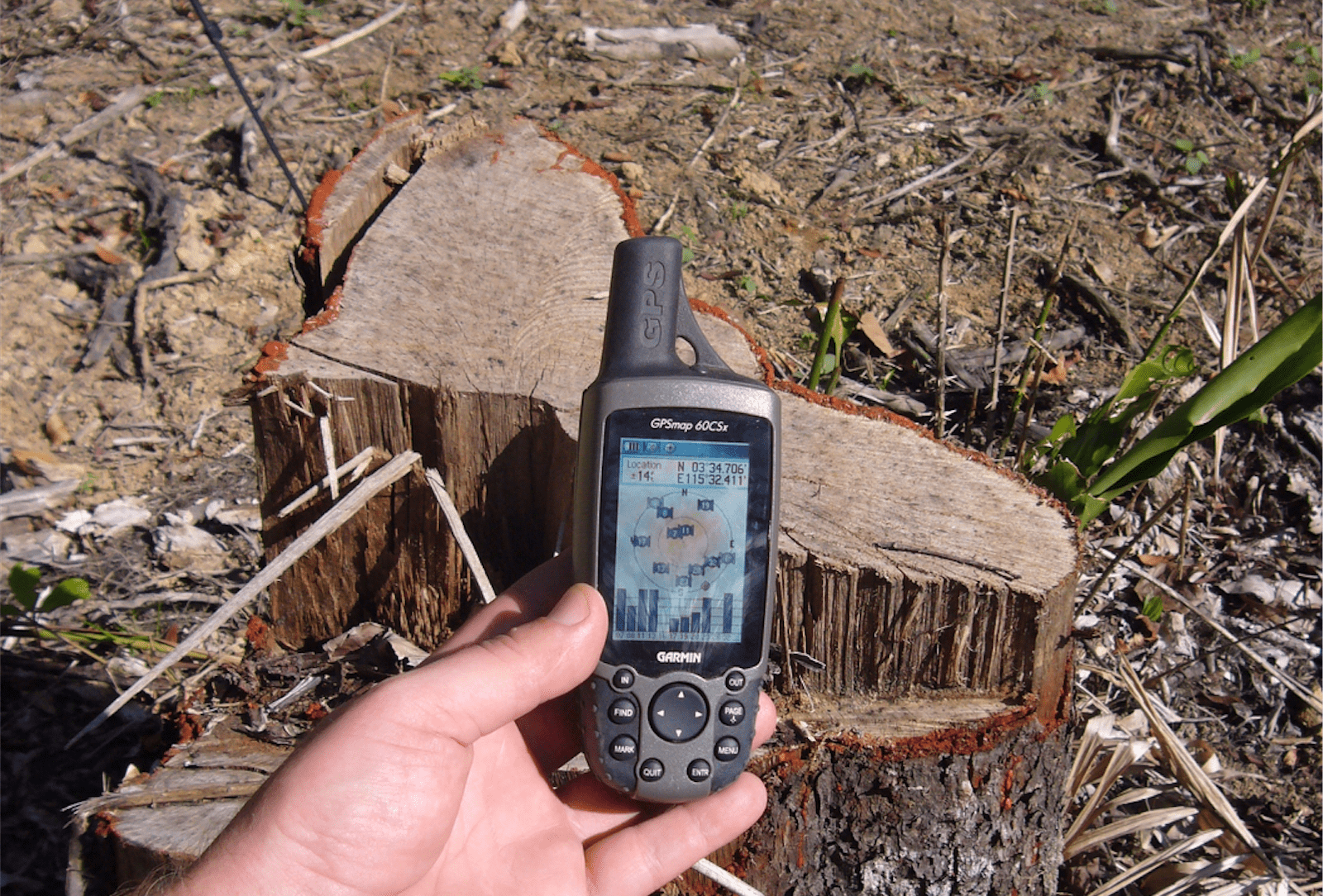
Photos taken during field investigations are most effective
when combined with GPS data. This can be achieved through the simple process of
including GPS devices in pictures, so the screen displaying latitude and
longitude is visible. This is useful post-fieldwork, to cross-reference field
evidence with contextual spatial data, such as logging stumps with concession
maps. But it is perhaps more important to provide proof to enforcement agencies
or other stakeholders. Though simple, there is an art to taking pictures
including GPS devices, due to screen reflections and the need to ensure that
both the evidence and the numbers shown on the device are in focus. It is
something that comes with practice, and practice should be done before the
fieldwork. Reasonable knowledge of how cameras function, to adjust depth of
field, is useful. Photos must be checked to ensure that both GPS coordinates
and subject are clear, and retaken if necessary.

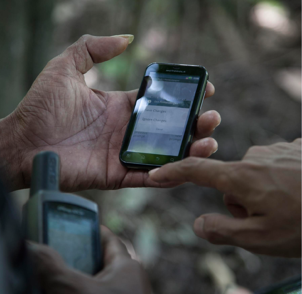
Smartphones all now include cameras and GPS devices. Google has developed a set of tools, Open Data Kit (ODK), that enable this hardware to be deployed for data gathering in remote areas. ODK allows users to:
- Build data collection forms or surveys;
- Download the form to a smartphone and collect data;
- Send the data to a server and extract it in useful formats.
ODK and similar systems, of which there are many, are being
applied for forest monitoring in Guyana, the Congo Basin, Indonesia, Myanmar,
Colombia and Suriname, to name a few. The advantage of ODK over some other
systems is that it can be deployed simply and quickly, and is free. Other
systems may be more suitable depending on a range of criteria. More information
can be seen at opendatakit.org.
If these technologies are employed, or investigators are using a camera or smartphone with GPS embedded, they should also bring and use a simple standalone GPS device as a backup; these are more rugged, have longer battery life and better reception.

High-res satellite imagery

The highest-resolution imagery displayed by Google Earth is
around 60cm, which means that each pixel on a computer screen will represent
60cm on the ground. Often mistaken for aerial photography, this is high enough
resolution to view logging roads, trucks, even individual trees and logs. It
exceeds the 5m resolution that is the highest available for free on Global
Forest Watch. However, it is only provided for some areas, with most displaying
Landsat imagery at around 15m per pixel, and is only intermittently updated.
It is possible to search for, preview and buy additional
highest-resolution imagery (including the Worldview imagery used by Google
Earth) directly from commercial providers. A useful tool for identifying
available imagery is the ‘Image
Hunter‘ provided by Apollo Mapping. This imagery is expensive to buy, at
US$16 per square kilometer (km2), with a minimum order covering 25km2. In some
cases, it is nonetheless possible to preview imagery for free (including for
Worldview imagery). These previews are less than full resolution, but
nevertheless provide higher resolution than that available from Landsat
imagery.
Satellite imaging is a fast-moving field, with several organisations working to increase the accessibility of high-resolution, processed imagery. It is likely to become increasingly accessible and useful for forest monitoring.
Online sources of information
Large volumes of relevant data are available online, even
where it relates to opaque countries. Relatively simple use of search engines
can provide access to permits, background on companies and identify routes to
market. However, ensuring that all possible avenues are exhausted requires the
application of good practice in where to look and how to search.
Where initial searches produce huge numbers of results of
possible interest, intelligent use of search terms is essential for picking out
key information. Searches can be restricted only to results from the website of
the relevant government agency, for example, or restricted only to results
contained in certain file types of interest, such as Excel or PDF files.
Searches can also be worded so that only results containing both a given
company name and a specific permit type are shown. Most search engines have
‘advanced search’ forms to help, but it is usually also possible to limit
searches more easily using additional text within the normal search box (for
example, adding ‘site:[domain name]’ to restrict results to those from that
domain).
It is important to bear in mind that search engines are
imperfect tools. Some information may be found by one, but not by another, so
it may be worthwhile trying a few. Some online information may not be captured
by any search engine. Such ‘hidden web’ content includes information accessible
only via search forms on relevant websites (such as member information on
websites of certification schemes like FSC, or databases of old articles on
newspaper websites), information accessible only on registration (such as
official government databases of company financial and ownership records), and
archives of old web pages. It is also important to remember that information
obtained online may be unreliable or out-of-date.
While the main sources of permit or company information will
often be the websites of governments, companies, NGOs and certifiers, other
online sources are equally or more valuable where other relevant types of
information are concerned. For example, if they are used by a company of
interest, trade boards such as Alibaba.com can be an indispensable source of
information. Where the research is focusing on a particular area or species, it
can also be used to identify targets. It can present leads that guide covert
investigations into the trade [see Section 9]. Intelligence can also be gained from social media platforms. While this
can be related to companies, more commonly it will relate to individuals.
Facebook and LinkedIn in particular can be invaluable tools for identifying
connections between individuals. By working outwards, connections between
companies, trade links and even corruption can also be identified.
Freedom of Information Laws
Many countries have a local variation of what can
collectively be called Freedom of Information (FoI) laws. These laws are passed
to give citizens legal rights to obtain information held by the government, to
increase the ability of civil society to hold government to account.
These laws commonly set out the types of information that
should be accessible to the public on request, information that should
proactively be published, and information that remains subject to restrictions.
Commercially sensitive information commonly falls into the last category, which
presents challenges in accessing information pertaining to companies. The
willingness of government agencies to release information in line with the law
is varied, with governments frequently withholding information in violation of
the law. In Indonesia, for example, NGOs had to resort to the courts to force
the government to publish relevant data relating to timber harvesting and
processing.
Nonetheless, such laws can and have been used as critical tools to increase the ability of civil society to monitor the forestry sector and identify illegality in timber harvesting and trade. The Environmental Investigation Agency, for example, was able to understand and show the complex system for timber laundering employed by companies in Peru (see Case Study 6) using the law to access government data on exports and inspection reports for logging concessions.
FoI and Voluntary Partnership Agreements
FoI provisions specific to timber are built into the text of Voluntary Partnership Agreements (VPAs), legal agreements between the EU and several wood-exporting countries to encourage the supply of verified-legal timber. These impose some legal obligation to disclose information, even in states where no generic FoI law has been enacted.Most VPA texts include an Annex outlining what information should be made public, in various ways, to facilitate monitoring of legality. This generally includes a wide range of data, down to the location of individual logging titles and the location of valid processing facilities. It also includes aggregated data on annual log production. Implementation of VPAs has been slow and varied, so it may be the case that the data is not available, but that it should be accessible. Annexes on Public Information are included in VPAs in the following countries:
- Cameroon (Annex VII)
- Central African Republic (Annex XI)
- Indonesia (Annex IX)
- Liberia (Annex IX)
- Republic of the Congo (Annex X)
Developing a cover story
When trying to obtain information from companies using
undercover methods, the nature of the cover story must be decided on a case-by-case
basis, depending (among other things) upon the nature of the company and what
key pieces of information are being sought. The most obvious would be to pose
as a prospective buyer, but another option might be to pose as an academic
researcher. The clear advantage of the former is that companies are more likely
to give up their time if they sense a potential sale. The disadvantage is that
it is easy to be caught out – more likely as a timewaster, than as an
investigator – if the details and language of the trade are not right. By
contrast, companies (particularly the least legitimate) may be unlikely to give
up their time to a researcher. But if they do so, there is no need to pretend
to be knowledgeable about the trade. Obvious, even direct, questions can be
asked, even about legality and corruption. It is also less likely that the
interviewee will exaggerate or lie, in the way they might in an attempt to
impress a prospective buyer.
Once the appropriate cover story is decided, the
investigators should carry out research to ensure they can back it up. If they
are posing as buyers, for example, they will need to have a close understanding
of the type of products customers might buy, and the questions they may
reasonably ask without arousing suspicion. Often an investigator posing as a
buyer will be seeking information not normally requested – such as details of
the origin of wood used in a product (including copies of paperwork), or
identities of other customers – for which particular false justifications need
to be developed as part of the cover story.
They may also need to flesh-out their front identity so they can explain who they are to the companies they are approaching. This may include obtaining an email address specific to the purpose and potentially even establishing a fake company website. Depending on how the target was actually identified, investigators may also need to have a cover story ready for how they came to know of the company and obtained the contact details used.
Building company profiles
When a target company of interest has been identified, it is
useful to find out as much as possible about it, including information that may
appear unrelated or irrelevant to its specific activities in the timber sector.
This applies to companies at every stage of the supply chain.
This information should be collated as a company profile in a single document, that can grow as more data is found. A company profile may include the following information:
- Where the company is based;
- How big the company is, in terms of volume of timber it handles, the area of concessions/logging permits owned, or revenues;
- Who owns the company, whether individuals or shareholders;
- Key executives or managers within the company;
- Affiliated companies, particularly holding companies;
- Companies or areas it buys from, and sells to;
- Connections to other companies or individuals, with a focus on politicians;
- How the company finances its operations. For example, if it is reliant on bank loans or other financial instruments.
Understanding, as fully as possible, the nature of a company
can provide new investigative leads, particularly in terms of supply chains. It
can also give rise to other forms of illegality. In some states, for example,
it is illegal for people closely connected to politicians (individuals known as
Politically Exposed Persons) to benefit from natural resource allocation. It
may give rise to new avenues for pressure. For example, some banks or
investment funds will divest or suspend their relationships with companies
exposed to illegality, which can in turn place pressure on them to reform.
Online background checks can help reveal the political affiliations, other business interests, past corrupt or criminal activity, human rights or environmental abuses connected to a concession or mill. This provides valuable context to an investigation. For example, if there are powerful political interests involved, it may help explain why illegal loggers have been operating with impunity. It also helps identify risks that may be encountered during fieldwork.
Mitigating risks in fieldwork
Investigating illegal logging carries with it significant
risks, especially during fieldwork. In many countries, those investigating this
subject have been arbitrarily detained, seriously injured or even killed, and
anyone planning such work must take the risks seriously and take appropriate
steps to assess and mitigate them.
The nature and degree of risk in undertaking fieldwork will
vary significantly between countries and within them. In all cases, where the
objective is to document illegal activities, it is wise to assume some level of
risk. Field investigators may be subject to threats from loggers, company
security or arrest by police, whether warranted or not. Travelling into remote
forest areas, with limited or no communication with the outside world, they may
suffer an accidental injury, or a vehicle breakdown that leaves them stranded.
In any of these scenarios, the risk mitigation strategy centres around a careful assessment of possible risks, and the development of contingency plans including an established system of communication with someone not directly involved in the fieldwork. The following steps provide some guidance and should be adapted according to local circumstances. Ultimately, if the risk is too great then the only suitable mitigation may be not to undertake fieldwork at all.
- Prior to every investigation, a written assessment of the possible risks should be prepared.
- Where a field investigation is expected to include areas outside of mobile/cellular telephone coverage, a satellite phone should be taken as an emergency backup; these can usually be rented for a reasonable cost.
- Field investigators should develop a clear plan and itinerary, determining the days on which they expect to be in certain locations. They should seek to determine if and when they will definitely be out of contact by phone or other means.
- The plan should be shared with a trusted contact, ideally a member of the team, who will not be involved in the fieldwork, and who agrees to ensure they are contactable by mobile phone 24 hours a day during the period of the fieldwork
- The field team must establish a communication plan for checking in with the nominated contact, making note of limitations to phone access. The plan should determine what action will be taken in the event that contact is not made within a pre-determined margin of the specified time. This may include reaching out to other contacts known within the given area, or notifying officials where safe and appropriate. The plan should include contact details of relevant individuals to be contacted in different emergency circumstances, including mobile phone numbers.
- In some regions, it may be appropriate for field investigators to identify a lawyer who can be contacted in the event they are arrested or detained. Ideally the lawyer should be contacted prior to the fieldwork.
- Field investigators should use tried and trusted drivers where possible and ensure they are aware of the sensitive nature of the task; they should also carry out basic checks of vehicles (such as checking the spare tyre) before setting off.
- Field investigators should have some form of cover story that justifies their presence in a particular area. This should not be elaborate, and should be as simple as possible. An example might be carrying out research on behalf of a university, or tourism.
- Field investigators should ensure that they bring attention to themselves (such as by pointing a camera out of a car window) only to the minimum extent necessary to obtain key evidence; lower priority tasks (such as capturing video and photos to help ‘illustrate’ a report) should only be carried out after priority tasks have been completed.
- Investigators should determine how they will communicate with local communities, and the extent to which their full purpose that should be shared. It is important to be honest whenever possible.
- Investigators should ensure that where communities share information, they have agreed to the terms in which that information can be used. This is particularly important where the information is directly attributable to them. This agreement should be clear, unambiguous and respected.
Investigators should ensure that data is managed in such a way that any sensitive information does not fall into the wrong hands, in the event they are arrested or detained by company staff. At a minimum, phones, laptops and other hardware should be password protected. Hardware should be kept ‘clean’ of any incriminating or sensitive data, which can be stored on an external hard drive. Ideally, data should be encrypted and hidden from obvious access. Encryption software is easy to use and free to download.
Contacts
Useful contacts are provided below, including for agencies
and organisations with responsibilities for implementing and enforcing EUTR and
the Lacey Act. Communities, activists and civil society organisations can send
pertinent information to these agencies directly, though we recommend that you
speak to Earthsight first, since we have personal relationships with key
individuals and can help ensure your information reaches the right person and
gets the appropriate attention.
EUTR Competent Authorities
Each EU country has a nominated ‘Competent Authority’
responsible for implementing the EUTR, which should be contacted by communities
and activists who have pertinent information to share regarding illegal or
high-risk timber destined for that country. A full contact list of the
Competent Authorities in all 28 Member States plus Norway (which implements
EUTR through its membership of the EEA) is available here. Names
of specific individuals working within some of the Competent Authorities are
available here.
European Commission
Though it has no direct enforcement role, the European
Commission helps monitor the implementation of the EUTR by individual EU
countries. It also provides official guidance on
the interpretation of the law, and is responsible for maintaining a list of
approved ‘monitoring organisations’ empowered to help companies practice due
diligence in their wood purchasing. Further information and contact details are
available here.
EUTR ‘Monitoring Organisations’
The EUTR allows for the formal recognition of ‘monitoring
organisations’. These are companies which are empowered to formally assist
timber and wood product traders, by providing them with a suitable due
diligence system and evaluating their implementation of it. Monitoring
Organisations are obliged to report repeated failures to observe due diligence
to the Competent Authorities in the relevant country. Competent Authorities, in
turn, are responsible for checking on the activities of the Monitoring
Organisations and penalising them for breaches of their responsibilities under
EUTR. A list of Monitoring Organisations and the countries they are approved to
operate in is maintained by the European Commission here.
EFI FLEGT Facility
The European Forest Institute (EFI) operates the ‘EU FLEGT
Facility’, which works on behalf of the EU in implementing its Action Plan on
Forest Law Enforcement, Governance and Trade (FLEGT), of which EUTR is one
element. The Facility’s main role is in the negotiation and implementation of
the FLEGT Voluntary Partnership Agreements (VPAs) between the EU and timber
producing countries. The Facility’s website has advice and background about EUTR.
The facility has nominated staff for each producer country negotiating or
implementing a VPA. Contact details for the facility are here.
US Fish & Wildlife Service (USFWS)
Overall responsibility for enforcing the US 2008 Lacey Act
amendments lies with the Office of Law Enforcement of the US Fish and Wildlife
Service (USFWS). Email and phone contact details for the Office are available
on their website.
APHIS
Responsibility for overseeing implementation of the
Plant Declaration requirement under the US 2008 Lacey Act amendments falls to
the Animal & Plant Health Inspection Service (APHIS). Further information
and a contact email address can be found on the relevant APHIS
Lacey Act web page.
Justice Department
The Environmental Crimes Section of the Environment and
Natural Resources Division of the US Department of Justice is the agency
responsible for prosecuting individual cases of breaches of the Lacey Act.
Contact details for the Division, and the name of the Chief of the Section, are
available on the Department of Justice website, here.
Australian Illegal Logging Prohibition
Australia passed legislation similar to Lacey and EUTR in
2012. The law is known as the Australian Illegal Logging Prohibition Act.
Anyone with information regarding illegal timber destined for Australia should
contact the relevant authorities. Background and contact details are
provided here.
Client Earth
Client Earth are a European NGO which encourages and provides assistance to civil society organisations in collecting and submitting information regarding the EUTR. Their teams of professional lawyers are particularly well placed to provide advice on submitting concerns from a legal perspective. Their web pages on EUTR can be found on their website, which also includes contact details. An animated video explaining the importance of evidence supplied by communities and activists to the implementation of EUTR is available here.
Next: Laws